Crossrail UXO Risk Assessment – Pre-empting best practice
Document
type: Technical Paper
Author:
Dr Phil Smith BEng MSc ACGI PhD DIC, Dr Ursula Lawrence PhD Eur.Geol C.Geol FGS C.Sci, Sarah Terry MSc C.Geol FGS, Simon Cooke BSc MA MBA MIExpIE MAPM MIoR, ICE Publishing
Publication
Date: 03/11/2014
-
Read the full document
Introduction
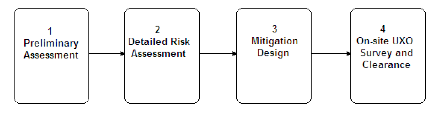
The publication in October 2009 of the CIRIA report C681 Unexploded ordnance (UXO) A guide for the construction industry (CIRIA 2009) has for the first time established an industry wide best practice for the assessment of unexploded ordnance (UXO) risk to construction activities in the United Kingdom. This guide shows how potential UXO risk can be assessed and managed through a staged approach of preliminary risk assessment, detailed risk assessment, risk mitigation and implementation (see Figure 1).

Figure 1. UXO Risk Assessment Procedure from CIRIA C681, showing the four main steps of the CIRIA UXO risk assessment procedure
Since much of the UXO that forms the hazard, thus generating the risk, dates from World War Two (WWII), the requirement to assess UXO risk in some recognised, consistent and professional manner has long been understood, not only by developers but also by designers and principal contractors.
This paper sets out how a procedure for UXO risk assessment was developed and implemented to support ongoing ground investigations being undertaken on behalf of Crossrail Limited for the Crossrail project prior to the CIRIA guide being commissioned, and how this procedure contains a staged assessment compatible with what the CIRIA guide has now established as recommended practice in the UK.
This paper provides a case study in how UXO risk can be assessed and mitigated through a logical process, commencing with data collection and analysis, followed by a review of available risk mitigation techniques, which identifies any limitations that may apply, enabling sensible and effective mitigation measures to be put in place where required. It shows the importance of considering any particular risk not in isolation, but in association with all relevant risks to the site activity, such that appropriate risk mitigation measures are applied where necessary, while ensuring that unnecessary or ineffective measures are not undertaken.
The Crossrail Scheme
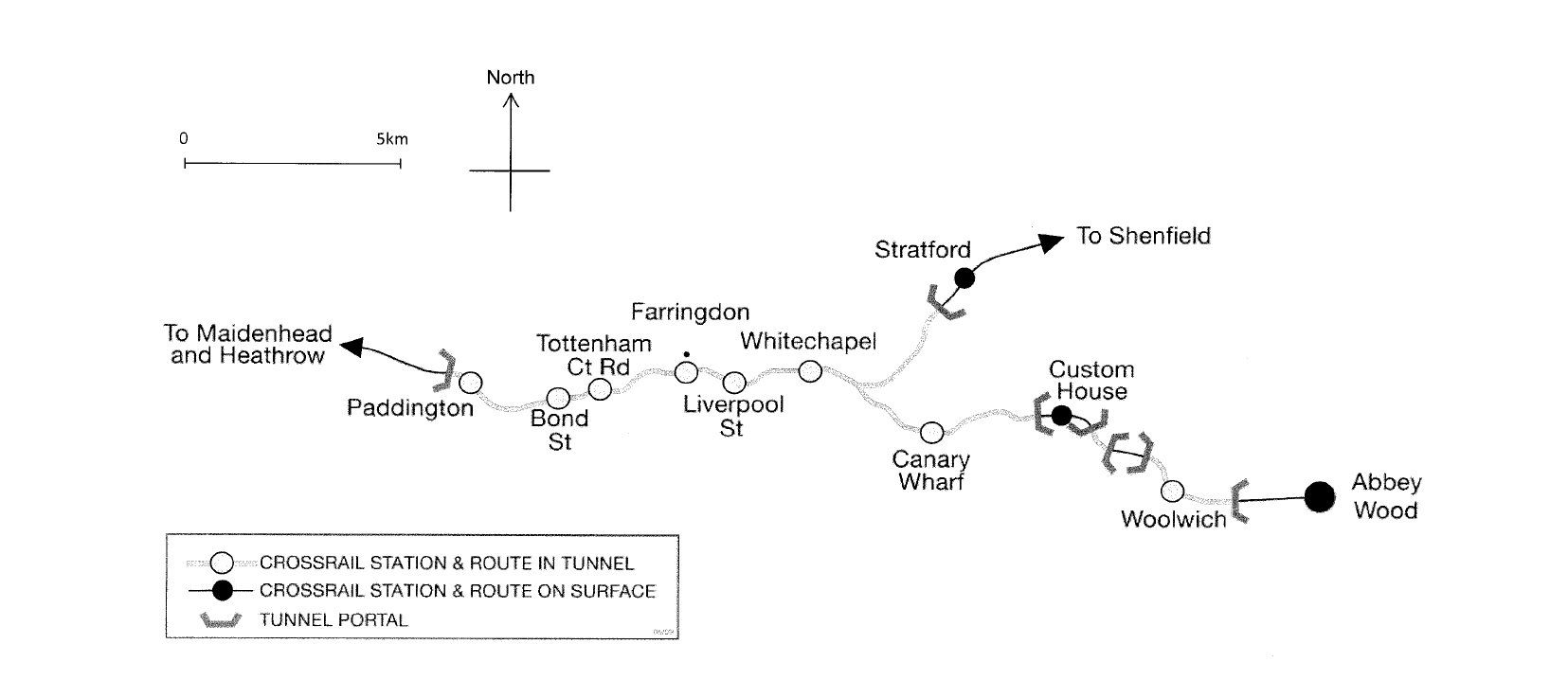
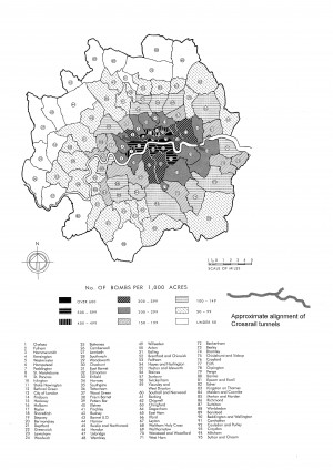
Crossrail is a proposed rail link connecting Maidenhead in Berkshire through Central London to Shenfield in Essex and Abbey Wood in Kent. Most of the route across London is to be within twin tunnels, each of which are approximately 6.5m internal diameter. The tunnelled alignment runs for 21km from Royal Oak Portal which is situated west of Paddington, to Pudding Mill Lane Portal at the River Lea (near Stratford) and Plumstead Portal to the east of Woolwich, see Figure 2. As such, the route passes through those areas of London most heavily bombed during WWII, including the City and docklands, as shown in Figure 3.

Figure 2. Central section Crossrail route, showing the Crossrail alignment across London from Royal Oak Portal in the west to Pudding Mill Lane and Plumstead Portals in the east.

Figure 3. London WW2 Bomb Density plot (After LMA 2005, redrawn from PRO HO193/53), showing the numbers of bombs per 1000 acres to fall on London during WW2, with the Crossrail central (tunnelled section) alignment shown superimposed.
Crossrail ground investigations and the need for the UXO risk assessment procedure
Crossrail was originally proposed in the early 1990’s, and initial ground investigations were undertaken at that time across West London, between Paddington and Liverpool Street inclusive. However, no specific measures to address UXO risk to the ground investigations are understood to have been applied at this time. Due to the prevailing economic conditions, Crossrail was then suspended until 2000, when works re-commenced.
Revisions to the scheme alignment saw the route extending further east than had previously been proposed, to approximately the current alignment, and ground investigation works re-commenced in 2001 to obtain geotechnical and geological data, with the initial focus on the eastern section of the route not covered by the earlier investigation works. The first of these new investigations were undertaken through the eastern central portion of the proposed alignment, and were again undertaken without specific UXO risk assessments or mitigation.
However, in 2004, a package of ground investigations was planned through the Silvertown area, between West India Dock on the Isle of Dogs and North Woolwich. Given the intensive bombing that occurred in this area during WWII, it was clear that some assessment of the UXO risk, and potentially mitigation measures to reduce it, would be required.
The initial response was to commission a desk study report on the UXO risk from one of the established UXO contractors. However, while the specific locations of the proposed site investigation works were provided, the resulting desk study report proved of limited value, since it did little other than confirm that each of the proposed investigation locations lay within an area of high bombing density during WWII, and was accordingly in a ‘high risk’ area, in relative terms.
As a result of this, it was decided that all intrusive ground investigations undertaken on this package of works were to be preceded by intrusive Cone Penetration Test (CPT) -based magnetometer surveys (mag-cone), to prove the absence of UXO. However, during the course of those works, this approach was found to be untenable, firstly because the use of mag-cone screening added considerably to the direct cost of the works, and to their duration. Second, in many locations, the combination of shallow obstructions within the ground, such as buried concrete and/or brick in the Made Ground, and/or underground services/utilities, required multiple attempts to penetrate into the ground with the mag-cone. Third, the results from the mag-cone were often inconclusive, because of significant, background electromagnetic ‘noise’ generated by ferrous metal objects within the ground.
It also became clear that by making many more penetrations into the ground than was strictly required for conventional ground investigation, while the UXO risk was reduced slightly, the risk of a utility strike was much increased, and that therefore the overall risk faced by the ground investigation works in some cases was considered to have actually increased by those UXO mitigation measures that were, or might have been, undertaken.
Accordingly, following the end of works review meeting, Crossrail Limited (Cross London Rail Links Limited as was), as client, and Geotechnical Consulting Group (GCG), as Engineer, jointly developed a UXO risk assessment procedure, for application to all intrusive ground investigation works to be undertaken on behalf of the Crossrail project. The procedure, once developed, was reviewed and amended by 6 Alpha Associates, an external UXO consultancy, before being fully implemented.
Developing the Risk Assessment procedure: False Starts
The initial attempt to develop an UXO risk assessment procedure adopted a purely quantitative risk assessment procedure. However, it soon became clear that for UXO assessment work, this approach was unsuitable. The most simple approach of Risk = Probability multiplied by Consequence, does not work well, at least not in a practical and meaningful way, especially for UXO assessment where the probability of encountering and initiating UXO is very low (tending to zero), but the consequence is very severe, including potential multiple deaths (consequence tends to one).
Therefore, attempts were made to produce a procedure that gave much better discrimination: it was considered that it may be possible to determine the approximate statistical chance of encountering UXO if bombing density records were consulted. However, this approach was also considered deeply flawed. One reason for this was that historic bombing density records tend to be recorded and organised along WWII local government administrative boundaries, as illustrated in Figure 3, where the bombing density is related to the boroughs of London in WWII. Clearly though, WWII bombing was not undertaken to a precise or uniform density across a county or borough, with a resultant reduction, or perhaps increase in bomb density at the local authority boundary. Rather, bombing within an administrative boundary is likely to be concentrated around a particular area target. Therefore, the strict employment of average bomb density records for a given area would tend to over-estimate the probability of UXO in some areas, and under-estimate in others (perhaps where the UXO risk is likely to be higher and thus the real risk may have been masked).
Moreover, it was recognised that while the records of bombing of targets in the UK are reasonably good, they are, by the nature of the way in which they were observed and collected (ie in extremely hazardous and uncertain circumstances during or between bombing raids) understandably incomplete. Additionally, there are numerous other ‘secondary’ sources of UXO that should also be considered, e.g. hidden caches of Army/Home Guard munitions (both conventional and improvised varieties), high explosive pipe mines or cratering charges laid for Home Defence purposes as well as locations where either munitions were manufactured, stockpiled or transported, and may have been discarded or deliberately dumped. None of these factors would have been identified from the bombing density records.
Accordingly, whilst the bombing density information and records were borne in mind, the UXO risk assessment process adopted a qualitative approach.
The Adopted Risk Assessment Procedure
The philosophy behind the adopted qualitative risk assessment procedure was to look at historic land use in conjunction with bombing records for a particular site, to identify where there was a credible risk of UXO remaining on site and therefore of potentially being encountered. This risk was then reviewed relative to the site conditions and specific ground investigation technique(s), as well as the other known or potential underground hazards on the site, in order to determine what practical UXO risk mitigation measures could be undertaken that would be effective in reducing the holistic risk to the proposed works: for example, undertaking additional intrusive works to mitigate a low UXO risk may significantly increase the already high risk of striking uncharted services, thus actually increasing the overall ground investigation risk. The stages of the qualitative risk assessment procedure are illustrated in Figure 4 and are described in detail below.
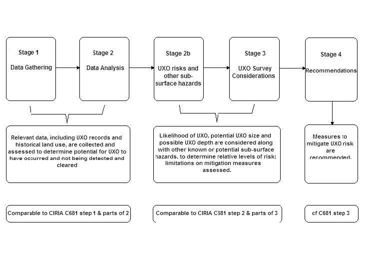
Figure 4. Crossrail qualitative UXO risk assessment procedure, showing the five main stages of the Crossrail UXO risk assessment procedure, and how these relate to the steps of the CIRIA guide C681.
Known UXO records
Stage 1 of the procedure started with the collection and assessment of the known bomb records. Details of average bombing densities were gathered (which were obtained from one of the established UXO consultants, but they are also widely published), along with bomb damage maps (LMA, 2005) while UXO records of so called abandoned bombs (i.e. UXO reported, but not cleared or discredited) for the London area were obtained from a number of sources, most notably from a list published in response to a parliamentary question (since reproduced in CIRIA C681), and from direct requests made to the archives of 33 Engineer Regiment (EOD), Royal Engineers. The Royal Engineers’ records also provide details of those UXO that were located and cleared both during and post WWII, thus improving the understanding of the severity of bombing in any area under review.
For the whole Crossrail route, a UXO desk study had been commissioned from one of the established UXO consultants who employed many of the same primary data sources, supplemented by their own records of munition production facilities, military airfields, anti-aircraft artillery battery locations, etc.
Review historical land use
During stage 2 of the procedure, the study of known or likely bomb impacts was supplemented by reviewing the historic Ordnance Survey (O/S) mapping sheets for the area under review (at 1:2500 and 1:1250 scales, where they were obtainable). The purpose of the O/S map reviews was firstly to look for signs of bomb damage, by comparing land use prior to WWII to that shortly after it. For example, large areas of cleared land where formerly there was terraced housing provided an obvious indication of possible bomb damage. Notations of ruin, or the replacement of terraced properties by small detached properties (most likely post-war prefabricated housing), provided a similar indication of potential bomb damage, and therefore the likelihood of encountering potential unexploded bombs (UXBs).
The map review also provided an indication of land use during the war, giving an indication of likely targets in the area and enabling the potential for UXO to have remained undetected, or been detected but not cleared. Where land was undeveloped and not overlooked (i.e. by casual observers or neighbours who would have perhaps noticed an UXB), the potential for a UXB to fall unnoticed was deemed a higher probability.
Conversely, it was assumed in the methodology that those areas that may have been bombed which were continuously occupied and/or involved in processes important to the war effort, such as railways or factories, would have had fire watchers and other regular inspections, so it is unlikely that UXO would have fallen in these locations undetected, nor would the authorities have left known UXO in such locations.
Finally, the map review was extended to include all available mapping to present day, to enable an assessment of any post-war redevelopment of the site. Extensive, deep ground works in particular would provide a significant opportunity for UXO to have been detected, if present, while reductions or increases in ground level may reduce the volume of soil within which the risk of UXO need be considered.
This process enabled a qualitative assessment of UXB risk for the relatively small areas that constituted individual ground investigation locations, being routinely applied to areas of a few tens of square metres. The resulting assessment provided an indication of the relative UXO risks, rather than an absolute number, and the requirements to mitigate those risks were then dependent on a further stage of assessment, stage 2b, which involved the following process.
Assessment of potential for mitigation
The geology of the site was reviewed, to determine the maximum likely bomb penetration depth for the site, and also to assess the likely maximum horizontal movement of an air-dropped bomb through the ground (bombs dropped by aircraft have a forward velocity as well as a vertical velocity, so tend to move downwards and laterally through the ground, if they do not detonate on impact). Unexploded bombs also commonly conform to a so called “j-curve” underground, often coming to rest at a depth that is shallower than their theoretical (or actual) maximum; see Figure 5. For more details of the sub-surface behaviour of bombs, see for example Smith and Hetherington (1994). Typically, the maximum horizontal distance between the point of entry of a bomb into the ground and its final position is taken as one third its maximum vertical penetration into the ground. The maximum penetration of a bomb into the soil is highly dependent on a range of factors including geology, the presence of surface structures, bomb type (including shape and mass), height and speed at which it was released, etc. However, maximum penetration is generally held to be no greater than about 20m (in most situations, very much less). The maximum horizontal distance a bomb is likely to move through soil is therefore typically less than 7m.
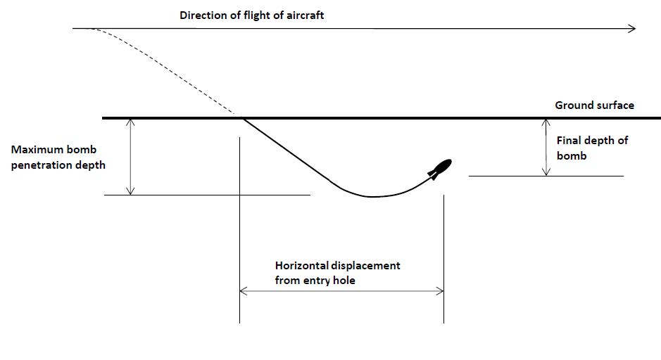
Figure 5. Sub-surface trajectory of a bomb: The ‘J-Curve’, illustrating the typical path of a bomb passing through soil, and demonstrating both vertical and horizontal displacement from the initial point of impact.
The mapping review included consideration of land use from the point of assessing whether munitions may have been produced, stored, transported or used (e.g. on firing ranges) either on or about the site under review. Consideration was also given at this stage to any known records of services or structures at the site, since they represent non-UXO hazards that may have significant associated risks.
Other associated site factors that are likely to impact on UXO mitigation measures were then considered within stage 3 of the risk assessment: generally, active mitigation of UXO risk on site requires the use of a magnetometer, employed either non-intrusively from the surface (where they can be easily affected by shallow buried ferrous metal contamination), or intrusively into the ground (where they often can deliver a higher degree of resolution). The purpose of mitigation is not to find UXO per se, rather it is to show that a location is clear of UXO to permit intrusive ground investigations to proceed without risk of encountering it. However, there is no clear benefit in attempting to use a UXO risk mitigation technique that will be either ineffective, or that results in an overall increase in risk.
Mitigation limitations
During the development of this risk assessment procedure, a trial was undertaken employing non-intrusive magnetometry. The trial site was at a proposed Crossrail borehole location in east London, which was a grass-covered open space (though not a ‘green-field’ site), at which the near-surface geology consisted of Made Ground and reworked soil. The trial used a FEREX 4.021 system, and indicated that even in this relatively benign (for London) environment, non-intrusive magnetometry was ineffective, since the Made Ground resulted in numerous ferrous contacts being recorded. While the proposed borehole at this site was later cancelled for unrelated reasons, another borehole completed nearby indicated that the Made Ground extended to approximately 6m below ground level, and was composed primarily of sandy clay, but with much demolition waste, including brick fragments. The presence of greater thicknesses of Made Ground (particularly where there was red brick contamination, because “fired-clay” also interferes adversely with magnetometers), sub-surface services and utilities, nearby metallic or reinforced concrete structures (including sub-surface rail tunnels, sheet piling etc) would all cause additional “noise” potentially masking any UXO present.
Moreover, the maximum depth to which surface magnetometry can detect ferrous objects, while variable according to such factors as the mass of the object and the angle of its orientation in the earth, is quite limited, and for most ground conditions is insufficient to “clear” a borehole location to the maximum credible depth of penetration of even a relatively small UXO. The practical limit of detection will rarely exceed 3m below ground surface, and will typically be less.
As a result of this trial, surface based magnetometer surveys, while always reviewed as an option, were considered to be generally unsuitable for all the Crossrail ground investigation locations. However, for shallow intrusive works on green field sites such techniques may be appropriate; expert guidance is often required in order to select the most appropriate option.
Intrusive magnetometer surveys can be undertaken either using so called mag-cone CPT, or as a down-hole magnetometer, where the instrumented probe is lowered within a borehole. Both techniques are able to clear the full depth of credible UXO penetration, but have other limitations: for example, mag-cone CPTs undertaken purely for UXO mitigation increase the number of penetrations into the ground, thus increasing the risk of an (uncharted, especially) service/utility strike. Additionally, mag-cones can be stopped by hard ground and often at a shallower depth than that associated with maximum bomb penetration. Both intrusive magnetometer techniques also provide only a limited radius of detection for ferrous objects. The maximum distance at which a UXO may be detected, whether horizontally or ‘ahead’ of the instrument at some depth below it, depends on the same factors as for non-intrusive methods, including type of instrument, ground conditions, other nearby ferrous objects, and size of target to be detected. Ranges of up to 6m may be achieved for larger UXO, though in practice, maximum detection radius for UXO is typically 1m to 3m depending on minimum size of target to be detected.
Down-hole magnetometers require non-magnetic casings to support the sides of the preformed borehole. Where down-hole surveys are undertaken, conventional steel casing can be used during boring, but has to be withdrawn when the magnetometer is lowered down-hole, leading to a possibility of collapse in the borehole; where the ground is self supporting this is not such a problem. Alternatively, internal plastic sleeving can sometimes be temporarily emplaced before the steel casing is partially withdrawn, though partial borehole collapse may still occur where the borehole walls are unstable. The use of non-magnetic casings to support the borehole during drilling is feasible, which avoids the risk of borehole collapse, but because it is a non-standard technique, the additional costs involved make this option too expensive for routine works. When employing a down-hole magnetometer, the process generally involves progressing the borehole in short stages. After each stage, the magnetometer is lowered down the borehole to confirm that the soil beneath the base of the borehole is free from ferrous objects and can be advanced without risk from UXO. The instrument is then withdrawn from the hole, and the borehole can then be progressed another step. The maximum depth bored in each step is a function of the detection radius for UXO; 1m steps are typical.
Thus, in reviewing potential UXO mitigation techniques, consideration needs to be given to the expected soil conditions such as whether there will be man-made or natural ferrous content, how stable the soil will be and whether it will stand uncased, etc. Consideration also needs to be given to other non-UXO hazards in the area e.g.: how many underground service/utility runs are know to be present, as well as how likely are uncharted or inaccurately recorded services to be encountered.
Mitigation recommendations
Having assessed all relevant factors as described above, the risk assessment concluded with Stage 4, the recommended mitigation measures. Six broad action levels were available for selection within the assessment process:
- No Action. Where the UXO risk was assessed to be minimal, no mitigation was justified.
- Relocate works. Where the UXO risk was not minimal, the risk might be mitigated by relocating the ground investigation works to an area where there was a lower assessed UXO risk. (Relocation in this instance refers to repositioning works a few tens of metres away). However, the location of ground investigation works was normally driven by the technical requirement for information, limited by the practicalities of obtaining physical and third party consent for access to locations, and in practice the option to relocate works to an area of lower UXO risk never occurred during the project.
- No Action, non-trivial UXO risk. Where the UXO risk was assessed as low, but not minimal, the recommended mitigation might still be to take no action other than toolbox briefings for the site staff. This situation would arise where the consideration of on-site conditions indicated that more active mitigation measures would be ineffectual, or would result in an increase in the overall risk (for example due to increased potential for service strikes). The content of the toolbox talk would be the responsibility of the ground investigation contractor undertaking the investigative works, and would be expected to be delivered by a UXO specialist. The talk would usually include a brief description of the UXO type(s) that might be locally encountered, and a warning concerning unexpected obstructions, particularly when boring in what was believed to be natural ground. The toolbox talk should include the depth range over which the UXO risk was considered to occur.
- Non-Intrusive Mitigation. Where the assessed risk from UXO was deemed low to moderate, and geological and manmade conditions were such that surface magnetometry was felt to be practical, non-intrusive mitigation would be recommended. For the reasons articulated earlier, this technique was not used at any of the Crossrail ground investigation locations where work has been completed to date.
- Intrusive Magnetometry. Where the assessed risk from UXO was deemed low to moderate, and non-intrusive techniques where considered impractical, intrusive mitigation was undertaken. The decision to use either mag-cone CPT or down-hole magnetometers was determined on a case-by-case basis.
- High Risk: Cancel intrusive investigation. Where the UXO risk assessment identifies an area as high risk, the recommendation was not to progress with proposed investigation works. Such a situation would typically only occur where an abandoned bomb was recorded in very close proximity, or where some other particularly unusual circumstances suggest that there was a significant probability of UXO being on the site (for example, at one site reviewed, 17 number unexploded bombs were dealt with during the war from a single incident; the possibility of other UXB from the same ‘stick’ of bombs being present, but having not been detected subsequently, was considered high enough to classify this as a high risk area). Where high risk areas were identified, these would be recorded in Crossrail’s risk register, and expert UXO advice would be sought before any works were undertaken at that location.
While the assessment procedure was undertaken by the geotechnical engineers responsible for developing the ground investigations, the process required that the completed assessment, including the final recommendations, were reviewed by an external, UXO consultant (in this case 6 Alpha Associates Ltd), whose sign off was required before the assessments could be issued to the ground investigation contractor. This external third party review was to not only to confirm that the process had been correctly followed, but also that the recommendations made were justified in accordance with the evidence presented.
Upon completion of this review process, the completed assessments where then issued to the ground investigation contractor, in accordance with the obligations under the Construction (Design and Management) Regulations 2007 to provide project specific information on significant risks. Only the completed assessments where issued, not the full desk study information utilised in generating the assessments, though this data was available for inspection by the ground investigation contractor if requested.
Notwithstanding the recommendations for UXO risk mitigation measures made, the ground investigation contractor remained responsible for their own safe method of working on site, and could challenge the recommendations of the UXO risk assessment procedure if they believed the recommendations to be inadequate. However, to date, this has not occurred.
Effectiveness of the Crossrail UXO Risk Assessment Procedure
The Crossrail UXO risk assessment procedure for ground investigations was developed in 2004, and used from November that year on all Crossrail ground investigations undertaken since: in excess of six hundred borehole locations were risk assessed, in locations from Royal Oak and Old Oak Common (to the west of Paddington Station) through the West End and City and on to Pudding Mill Lane in the east, and through the Isle of Dogs and Woolwich to Plumstead in the south east, as well as a number of smaller ancillary sites outside Greater London.
The application of the risk assessment procedure has enabled the vast majority of these works to go ahead without specific UXO mitigation measures, beyond a simple site brief. No confirmed UXO were encountered in any of these locations, though a single piece of unidentified metal was recovered from one borehole near Plumstead. In accordance with their tool box brief, the work crew immediately stopped work and reported the find to the Engineer. While it was initially considered unlikely that this piece of metal was associated with UXO, expert advice was taken which indicated that it could possibly be a fragment of bomb tail fin. Accordingly, the borehole was immediately abandoned and relocated, and the possibility of UXO presence recorded on Crossrail’s risk register.
Of the locations that were identified by the assessment procedure as needing specific UXO risk mitigation, the majority were in the docklands area, and all were mitigated using intrusive magnetometer techniques. As at the time of writing, 81 locations have been UXO risk mitigated through such measures, of which 42 were completed using mag-cone, and 39 locations made use of down-hole magnetometers. Of these 81 locations, 35 of the mag-cones and 5 of the downhole probes were undertaken at overwater locations in West India Dock and the River Lea, where the borehole and associated UXO risk mitigation work was undertaken from a work platform or existing structure built over water.
No confirmed UXO were recovered or detected at any location. In two boreholes, ferrous objects were detected at depth, and recorded as possible UXO, resulting in the ground investigation location being relocated circa 10m away. In one of these positions, it was suspected that the object detected was a redundant retaining wall tie, but records were not available to confirm this. The nature of the object in the second case remains unknown. In both cases, the unknown ferrous objects were recorded in the Crossrail risk register.
Where the possibility of UXO has been recorded in the Crossrail risk register, this information will be expertly assessed, and appropriate target investigation undertaken, as and when deemed necessary, to permit safe progression of the construction phase of the project. However, such works are well beyond routine ground investigations, and will require dedicated specialist UXO risk mitigation works.
Comparison to CIRIA C681
Figure 1 illustrates the four basic steps for UXO risk assessment and risk mitigation as now defined in CIRIA C681. Figure 4 shows the stages of the Crossrail UXO risk assessment procedure, and indicates how the activities required for each of these stages equates to a step of the CIRIA procedure.
The initial data gathering and analysis stages (stages 1 and 2) of the Crossrail procedure matches closely the CIRIA step 1, as it is in these stages that the potential for UXO to be present on the site is considered and hence the preliminary assessment of the UXO risk is made.
The second step of the CIRIA procedure requires a detailed risk assessment, in which the UXO risk at a particular site is quantified relative to the proposed works at that site. This requires consideration of the probable source of ordnance, ground conditions and penetration depths into the soil, etc, and is comparable to the Crossrail stage 2b, consideration of UXO risk relative to other ground risks and stage 3, UXO survey considerations. The two procedures do not perfectly match; for example, within the CIRIA procedure, ground conditions are not considered until this detailed assessment in step 2, whereas within the Crossrail procedure, these are reviewed earlier in the data analysis stage. Similarly, the Crossrail procedure considers the factors that might influence the feasibility of mitigation methods during the survey considerations stage, but such factors are considered within the CIRIA procedure during step 3, risk mitigation. Nevertheless, there is a good degree of agreement between the two procedures.
Within the CIRIA guide, step 3 is to assess the options for mitigating UXO risk and develop an appropriate mitigation plan. This corresponds to the Crossrail procedure stage 3 and stage 4, where the options for mitigation are considered, and the most appropriate mitigation method for the site is recommended. The Crossrail procedure recommendations fall slightly short of a true mitigation plan, since the recommendation is for the most appropriate general mitigation technique to be applied, but does not detail fully the exact locations and method of mitigation / equipment type to be used.
The CIRIA procedure is completed by step 4, implementation of mitigation measures, including disposal of UXO if encountered and verification. This step lies outside of the Crossrail procedure. However, it is the ground investigation contractor’s duty to progress the works in a safe manner, and they were required to address the recommendations of the UXO risk assessment within their site health and safety plan.
Notably absent from the Crossrail procedure was any specific plans for clearance of UXO if encountered. While the site health and safety plans included emergency action plans to enable site works to be shut down and expert UXO advice obtained if suspected UXO were encountered, the purpose of the risk assessment procedure was to allow ground investigation works to progress safely, not to undertake target investigation of suspected UXO followed by disposal. If actual UXO had been encountered, it was accepted that site operations would be seriously disrupted, but the emergency action plan would have ensured the site was safely shut down, and it was felt that the application of the Crossrail UXO risk procedure reduced the probability of actual UXO being encountered during the ground investigation works to a negligibly small level.
It is therefore clear that the Crossrail procedure, developed five years prior to the publication of CIRIA C681, involves the same basic steps of date collection, preliminary assessment, detailed (site-specific) assessment, consideration of appropriate mitigation options and recommendations for mitigation which form the core of a detailed risk mitigation plan. While the matching of the Crossrail procedure stages to the CIRIA procedures steps is imperfect, the similarities between the two processes are clear.
Conclusions
In response to a perceived “unmanaged risk” being posed by UXO to proposed ground investigation works, Crossrail developed a procedure for assessing UXO risk to the ground investigations. This procedure involved a review of wartime records and reported UXO/abandoned bombs, as well as taking into account site geology and local conditions, to enable a holistic assessment of UXO risk to be generated. It enabled areas with low or minimal UXO risk to be identified, so that investigation works could be undertaken without expensive, time consuming and unnecessary on-site mitigation.
It also enabled areas of moderate UXO risk to be identified, and appropriate site mitigation measures to be undertaken. Similarly, it enabled areas of high UXO risk to be identified, where works cannot progress without expert help and advice.
As such, it is consistent in philosophy with the recommended practice set out in CIRIA C681, and demonstrates that a safe and effective UXO risk assessment procedure can be implemented without causing excessive cost or delay to a project.
This paper has illustrated how the Crossrail procedure was developed, and details the stages of the assessment procedure. It shows how an initially unquantified risk was assessed and managed through the application of a logical assessment process that addressed the specific work activity and considered risk to this activity holistically, rather than focus solely on a single risk which was not necessarily the most significant. In this way, the true aim of any risk assessment process – to make the work activity safer – was achieved.
References
CIRIA. Unexploded Ordnance (UXO): A guide for the construction industry. CIRIA. London. 2009. Report C681.
The Construction (Design and Management) Regulations, The Stationery Office, 2007. Statutory Instruments 2007 No.320, Health and Safety.
LMA. The London County Council Bomb Damage Maps, 1939-45. Publication No.164. The London Topographical Society / The London Metropolitan Archive. 2005.
PRO HO193/53: Bomb Census maps produced by the Research and Experiments Division of the Ministry of Home Security, held at the National Archives, Kew.
Smith, P.D. and Hetherington, J.G.. Blast and ballistic loading of structures. Butterworth-Heinemann. Oxford. 1994 -
Authors

Dr Phil Smith BEng MSc ACGI PhD DIC - Geotechnical Consulting Group
Senior Geotechnical Engineer, Geotechnical Consulting Group
Dr Ursula Lawrence PhD Eur.Geol C.Geol FGS C.Sci - Crossrail Ltd
Geotechnical Engineer, Crossrail
Sarah Terry MSc C.Geol FGS - Crossrail Ltd
Formerly Geotechnical Engineer, Crossrail
Simon Cooke BSc MA MBA MIExpIE MAPM MIoR - 6 Alpha Associates Ltd
Managing Director, 6 Alpha Associates Ltd