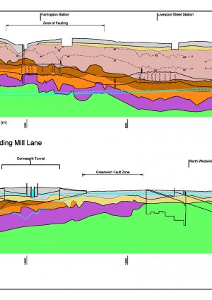
The links provide access to two documents produced by GCG for Crossrail; a geological long section along the Crossrail alignment in London; and a report that provides detailed notes for the section along with some context for the production of the section.

Prior to construction of Crossrail a large number of ground investigations were carried out for the project. The stratigraphic knowledge arising from this work was coupled with thirty party and historic borehole data to produce an initial long section along the Crossrail alignment to illustrate the likely geological conditions. This long section was updated towards the end of the main construction works with later Crossrail and 3rd party borehole data. This updated section is the subject of this report.
The purpose of these sections was to provide an overview of the geological setting of the whole of Crossrail; they were not used directly in design or for construction.
The locations of strata boundaries shown on the section are based on GCG’s interpretation of the available borehole logs. The scale of the section, the variable borehole density and the use of boreholes offset from the tunnel alignment all mean the strata boundary locations shown on the section are only indicative. In highly faulted zones individual faults are not shown. Faults are shown as planar and vertical, this is unlikely to be the case in practise.
The Harwich Formation and Lambeth Group boundary has been re-interpreted and reclassified in some areas and this re-interpretation may differ from other earlier published works. These new findings are presented and discussed in detail in Appendix A and B of the report.
The report also contains a series of explanatory notes for the long section. These are set out in Section 2. Key findings from the revised Section are presented in Section 3.


