Geographical Information System (GIS)

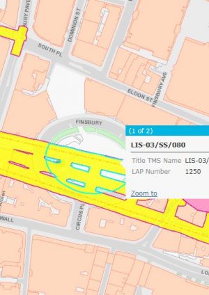
The Geographical Information Systems (GIS) team manages the provision of all geospatially referenced mapping data to the project. This includes the provision of mapping data to a number of other functions within the business such as CAD, Delivery and Land and Property, and also includes presentation of data through an organisation wide portal to allow all stakeholders to view geospatial information within a single interface.

In addition to feeding mapping data to the project, the GIS team also take data feeds from within the project, allowing greater visualisation and analysis of different aspects of the project, including Engineering, Land and Property, Asset and Utilities information which helps make better informed decisions during design and construction.

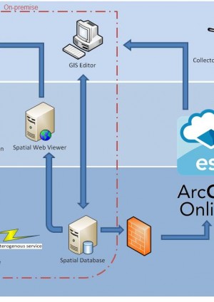
In order to achieve this state, a Spatial Data Infrastructure has been constructed to ensure that information is discoverable, accessible and accurate.  Once this was in place it enabled the direct assimilation of business data, including workflows for managing land and property information, into a common data environment from which content can be published. The common data environment has also allowed Crossrail to make the information accessible through the enablement of mobile mapping for Land Management.

GIS Documents:

Summary Publication date Document Type
The Geo-centric Railway – Why Location Matters in the Rail Industry

The Geo-centric Railway – Why Location Matters in the Rail Industry

Topic area: Geographical Information Systems (GIS)

The use of maps and mapping technology within the transport industry is growing as the larger digital revolution continues to disrupt and change the way in which traditional tasks are undertaken. The method of conveying information through cartographic output has been present within this industry, and particularly with...

02/05/2018 Journal Publication
Building a Spatial Data Infrastructure for Crossrail

Building a Spatial Data Infrastructure for Crossrail

Topic area: Geographical Information Systems (GIS)

Geospatial data has been a key building block in all phases of the Crossrail project and as such the quality, accuracy and range of data sources has been paramount to ensuring that planning, design and construction is delivered on time and on budget. This paper will explain the methods by which geospatial data has been...

26/02/2016 Case Study
Mobile mapping for land management

Mobile mapping for land management

Topic area: Geographical Information Systems (GIS)

A mobile GIS solution was deployed by Crossrail using easily customisable apps on mobile/tablet devices. Site boundaries and land ownerships were verified during Crossrail construction works to ensure health and safety regulation was adhered to. A cloud-based central repository ensured both site and office users had th...

26/02/2016 Micro-report
Workflows for Managing Land and Property Information

Workflows for Managing Land and Property Information

Topic area: Information Management and Technology

Crossrail needed to acquire and manage large areas of land during the Crossrail project, the purpose being to construct a new railway through Central London. This micro report outlines how the spatial element has been central to the management of this land from purchase and occupancy by a multitude of contractors, thro...

27/09/2016 Micro-report