A Geology of London for Tunnellers and Engineers
Document
type: Technical Paper
Author:
John Davis EurGeol CGeol MSc DIC
Publication
Date: 31/08/2016
-
Read the full document
Introduction
This short paper attempts to set down in non-technical language why some of the major strata units encountered by Crossrail are the way they are. The paper covers the Thanet Sand Formation, the Lambeth Group (the Woolwich, Reading and Upnor Formations), the Harwich Formation and the London Clay Formation.
Space constraints mean this story starts after the deposition of the underlying Chalk. The detailed geographic coverage of the paper is limited to London but the story encompasses diverse events taking place many hundreds of kilometres away.
In addition the paper briefly discusses the formation of the many Terraces created by the River Thames during the ice age. Feint echoes of processes set in train during these cold spells persist to this day and these are continuing to produce measurable ground movements.
The wider framework for understanding the geography of South East England in the narrow time frame (59 Ma to 49Ma where Ma = million years before present) is defined by the interplay between four globally significant factors:
- The opening of the North Atlantic Ocean between North West Scotland and Greenland and two associated phenomena; 1) the volcanic activity in the North West of Britain associated with this and 2) related tensions in the earth’s crust that deepened and widened the North Sea.
- The creation of the Alps, caused by continental collision between Africa and Southern Europe.
- Global changes in sea level caused by changes in the volume of the oceans and the volume of water they contain.
- A generally cooling global climate, varying over this period in southern Britain from hot ‘greenhouse’ conditions with little or no Polar ice to later climates cool enough for ice sheets to approach the northern edge of London.
The views set out in this paper could be considered to be mainstream and uncontroversial; however they are not all universal. The area has a long history of research and alternative views are still expressed on some aspects of this story.
Britain prior to deposition of the Thanet Sand
Immediately prior to the deposition of the Thanet Sands all of what is now Great Britain was land, i.e. above sea level, except for a thin strip of Eastern England. This compares to the situation towards the end of the deposition of the much older underlying Chalk where it is possible all but the upland of Wales, Northern England and Scotland were below sea level.
The post Chalk uplift that this contrast demonstrates was brought about by a combination of two distant events. Firstly an episode of compression from the South, representing an early phase of the continental collision that produced the Alps. The folding of the Chalk that can be seen on the Isle of Wight and in the Hog’s Back ridge in Surrey are visible manifestations of this compression.
Secondly there was the development of a major hot spot deep beneath the earth’s crust between Scotland and Greenland. This produced widening of the north Atlantic and the formation of volcanos in what is now the North Western edge of the British Isles. The volcanic rocks of St Kilda, Skye, Rùm, Ardnamurchan, Mull, Arran and Antrim are expressions of this activity. The active volcanos of Iceland are the current manifestation of this hot spot.
As well as forcing apart the North Atlantic this hotspot injected large quantities of material beneath the earth’s crust under Britain, producing significant pulses of uplift and a pronounced NW to SE tilt to the ground surface. Although it was modified much later by glaciation much of the current arrangement of river drainage in Britain still reflects this NW to SE tilt (short steep rivers draining to the West and longer less steep rivers draining to the East and South).
A further consequence of the tensions in the crust created by the hot spot was the widening and deepening of the North Sea. It is on the South Western margins of this developing sea that cycles of localised uplift, subsidence and consequent sea level change produce the strata that are the subject of most of this paper.
The estimated magnitudes of total uplift at this time are between 1500m and 3000m in the west and far northwest. This uplift would have been accompanied by significant erosion. Arising from this is a thickness of between 3000 and 4000m of sediments in the North Atlantic and Northern North Sea that are of similar ages to the strata discussed in this paper.
Thanet Sand Formation
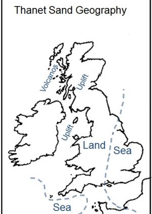
The Thanet Sands represent a near shore marine environment formed as rise in relative global sea level moved the coast line across the eroded and tilted land surface of England from close to the eastern edge of modern England to a line broadly running from Teeside to Dorset. See Figure 1. The southern part of this early North Sea didn’t have a connection with the Atlantic via the Western Approaches at this time as such a connection was blocked by prior uplift creating a low lying area of land between South West England and North Western France. This area of land was underpinned by the granites of Brittany Devon, Cornwall and the Isles of Scilly, the roots of earlier continental collision and mountain building.
The materials deposited in this Thanet Sand sea were silts and sands, with coarser material dominating near the shore (as under London). These materials were derived from uplifted land to the West and South West but also some exotic minerals seen in these sands suggest the source of the material was partly Scottish, probably transported down the East coast by longshore drift.
A thin layer of large flint nodules (the Bullhead Beds) seen at the base of these sands in London is a relic of prior erosion of the underlying Chalk. Weathered ash from the hotspot volcanoes to the northwest is also seen in these lowest Thanet deposits.
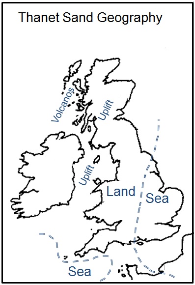
Figure 1 – Thanet Sand Paleogeography Lambeth Group
Lambeth Group times were short lived (56Ma to 55Ma) and under London produced only 10m to 20m of strata. Yet these strata could be said to present more engineering complexity than all the other strata discussed in this paper.
The Thanet Sand deposition was ended by another period of tectonic uplift and erosion and the related retreat of the coastline several hundred 100kms to the East. It was this uplift and subsequent erosion that restricts the Thanet Sand to its current onshore extent between London and North Kent. Under London the uplift produced a coastal plain that oscillated between being just above and just below sea level throughout Lambeth Group times. See Figure 2.
The Lambeth Group is divided by Geologists into 3 ‘Formations’, each reflecting a different environment. Each of these environments has a different relationship to sea level and the location of the shoreline. Overprinting this when the sea was absent were periodic episodes of intense weathering caused by the very warm and seasonally wet climate.
The key to unravelling the complexity in any particular vertical Lambeth Group sequence, such as seen in a borehole, is to think of the vertical variations in the type of material seen in the borehole in terms of the relative southeast-northwest position of the shoreline.
This is because different materials will be deposited at exactly the same geological time in different locations relative to the shoreline. During the Lambeth Group falls in sea level moved the shoreline South East and rises in sea level moved it North West.
To the south east or seaward side of the shoreline, shallow estuarine deposits dominated. To the north west and landward side of the shoreline, deposits associated with the periodic flooding of marshy plains dominated. Complicating this picture are deposits associated with infilled river channels. These can straddle the flood plain / estuarine boundary and cut down into the older materials they flow across. As well as estuarine inter-tidal and lagoon areas shorelines can also be marked by sand and gravel ridges that represent storm beaches.
The Lambeth Group is best considered from the bottom up. The lowest and oldest of the three Lambeth Group Formations is the Upnor Formation; this is usually about 6 to 7m thick in London. This is predominantly sand with variable clay and silt content deposited in a just offshore marine setting, i.e. the shoreline was to the west of London. In London the Upnor Formation is often seen to coarsen upwards from sand into beds of rounded gravel. This upwards coarsening represents a fall in relative sea level and the shoreline progressively retreating towards the London area from the west.
The other two Formations in the Lambeth Group are the Reading Formation and the Woolwich Formation. These are broadly contemporaneous.
The Reading Formation represents material created North West of the shoreline in marshy floodplains and river channels. The Reading Formation typically comprises brightly coloured mottled clays. The lighter bright colours (reds oranges and browns) arise from these materials being weathered in tropical mostly dry oxidising conditions and the darker colours (greens purples and blues) arising from wetter anaerobic conditions . The Reading Formation is also characterised by an absence of shells or sedimentary structures such as bedding.
The Woolwich Formation represents materials deposited in shallow brackish estuarine situations, i.e. those immediately south east of a high water mark shoreline. The Woolwich Formation typically comprises dark grey clays with many laminations of silt and sand along with clays containing many shells. The dark colour of these materials arises from their deposition in anaerobic reducing conditions.
A significant source of the clay in all these Lambeth Group materials is weathered volcanic ash from then active volcanoes of North West Britain.
The Lambeth Group shoreline that divides these two depositional environments oscillated back and forth under London several times. This oscillation was overlain by a general slow subsidence that was slow enough to broadly match the overall rates of sedimentation seen within the Woolwich and Reading Formations. Over the course of Lambeth Group times it is this overall subsidence that creates the ‘room’ for the Lambeth Group to be deposited. Geologists call this creation of ‘room’ for sedimentation to occur ‘accommodation’.
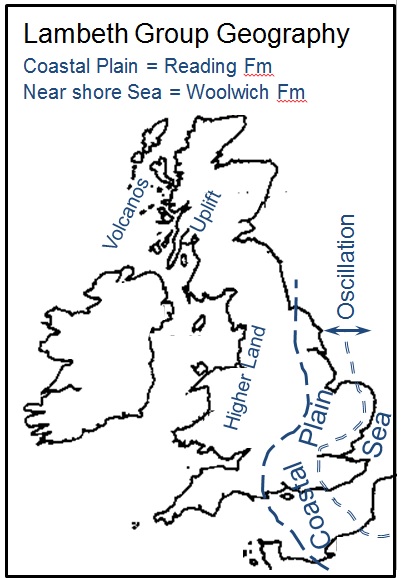
Figure 2 – Lambeth Group Paleogeography Identification of the back and forth cycles of shoreline oscillation in any particular London location is most easily done by looking for evidence of significant sea level fall. When the previously submerged estuarine deposits become exposed to the atmosphere several things occur that substantially alter the nature of these deposits.
1) The hot and seasonally wet climate produces intense chemical weathering. The largely dark grey clays of the Woolwich Formation become oxidised and change colour to various bright reds, yellows and purples. This weathering also tends to destroy any estuarine fossil remains that might otherwise have been present. This process is assisted by:
2) Colonisation of the emergent land by vegetation. Root activity tends to destroy any evidence of sedimentary structures (e.g. bedding and laminations) that might have been previously present. The best modern analogy for this Lambeth Group environment and climate are mangrove swamps in South East Asia. Geological materials like these that represent ‘fossilised soils’ where ‘soil’ mean material vegetation grew in, are characteristically mottled with bright colours when freshly exposed. As well as the Reading Formation such colouring can be seen in ‘seatearths’, the fossil soils often seen beneath coal seams.
3) In some cases the combination of uplift and chemical weathering is extreme enough or sufficiently long lasting to form very strong siliceous or calcareous ‘hard pans’. These can form as nodules or significant sheets or blocks. These can create difficult problems when they are encountered by engineering works. Away from London the ‘Sarsen’ stones seen across the Chalk uplands of Southern England and at Stonehenge are relict examples of these hardpans. In these locations they are the only remnants of the Lambeth Group after substantial later uplift and erosion.
Many of these effects arise from a short-lived and sharp upward spike in global temperatures in Lambeth Group times. The causes of this are uncertain. One plausible theory is that the previously mentioned pulsed thermal uplift of the Northern Britain might have caused the release of large quantities of methane hydrate (a powerful greenhouse gas) from the seabed, by reducing the weight of overlying seawater. This rapid rate of temperature increase and the planet’s later recovery from it are of great interest to scientists, because the rapid rates of temperature increase at this time are uniquely similar to those being experienced today.
The location of a significant fall in sea level can be identified in these materials by one or both of the following:
i) The presence of oxidised deposits (reds, browns and purples)
ii) The presence of hard bands or nodules of strong calcareous or siliceous rock.
Geologists call sea level fall markers like these ‘Sequence Boundaries’. Other environments will produce sequence boundaries with different characteristics. See the London Clay section for examples.
There were several significant falls in Lambeth Group sea levels sufficient to withdraw the shoreline away from the London area. From the oldest to the youngest these falls in sea level are found:
a) At the top of the Upnor Formation.
b) At the top of the Lower Mottled Beds of the Reading Formation
c) At the top of the Upper Mottled Beds of the Reading Formation
The fall in sea level marked by b) is the most important of these for Engineers and Tunnellers in London as this change is often marked by the presence very strong siliceous or calcareous ‘hard pans’ mentioned in ii) above. The strength and thickness of these materials can present significant construction difficulties. Geologists call this particular sea level fall or sequence boundary the ‘Mid Lambeth Hiatus’ because it represents a significant pause in sedimentation.
Where river channel infill deposits (‘sand channels’) are present, identifying episodes of sea level fall can be can significantly complicated. These ‘sand channels’ can be small and sinous or represent very wide (100s of metres) infilled river courses. Sand channels as a depositional environment can be found either side of the ‘shoreline boundary’ described above, as they are found in both Woolwich and Reading Formation deposits.
Lambeth Group Sand Channels
The filling of channels with sand in flat coastal floodplain environments requires an additional input of energy to both transport and deposit the coarser sands. There are two mechanisms by which this can come about. These mechanisms may operate together or singly.
i) An episode of uplift both lowers sea level and increases potential energy and therefore erosion upstream (remember uplift is generally much greater in the west than the east). The increased potential energy applied to the river system results in down cutting of channels towards the new sea level, sometimes deeply enough to cut down through the sea level fall markers set out above. This increased energy is also available to transport coarser material (mostly sands) longer distances. This sand eventually fills or partially fills the channel, usually by lateral meandering and the deposition of bars on the outside of bends. In these ‘uplift’ sand channels the location of the fall in sea level could be placed at the top of the sand filled channel.
ii) Alternatively sand channels may merely represent a change in the depositional energy in a river caused by individual significant storm events – i.e. an increase in erosion and transport caused by short term increases in flow. In these cases the top of a sand channel may not be coincident with a significant fall in sea level.
Identifying which mechanism applies is often not possible. In practice certain sub units of both the Woolwich and Reading Formations are more likely to contain sand channels than others, but in the context of smaller engineering projects where boreholes are the main source of information, the presence or absence of an infilled channel could be regarded as random.
A project on the scale and depth of Crossrail can however identify some areas where sand channels are more common. These are often (but not always) associated with geological faulting. The reason for this is the land surface is more easily eroded along the fault alignments and river systems tend to naturally pick out these weaknesses where they coincide with the general fall of the land. This point also applies to the position of modern day tributaries of the River Thames. So it follows that a reasonable presumption is that Lambeth Group sand channels are more likely to be found under the alignments of Thames tributaries. On Crossrail this correlation is demonstrated where the route crosses the Westbourne, the Tyburn, the Fleet, the Walbrook and the Lea. However there are also other locations where there are sand channels and faults, but no tributary. Charing Cross Road and beneath the Barbican are examples of this.
Sand channel infill deposits can contain the remnants of significant organic content washed out of the densely vegetated Lambeth Group landscape. These remnants are in the form of Pyrites (Iron Sulfide or FeS) content. The presence of air (perhaps from a tunnel) in such high pyrite content channel can lead to the creation of highly acidic groundwater.
Individual sand grains in sand channels (and in the Thanet Sand and Upnor Formations) are often coated in a very thin layer of complex iron hydroxides known as ‘green rust’. These chemicals have the ability to rapidly strip oxygen out of any air they encounter during tunnelling works. As a result great care needs to be taken during construction to recognise where this might occur and prevent the creation of oxygen free atmospheres.
Blackheath and Harwich Formations
The Lambeth Group was followed by a period of uplift, shoreline retreat to the east and erosion.
The Blackheath formation is only found in south east London where it forms the raised areas of Blackheath and Woolwich Commons. It typically comprises up to 5m of sand and mostly flint gravel, which are the products of erosion to the south, deposited in a near shore environment. In places these materials infill deep channels cut in to the underlying Lambeth Group and Thanet Sand. The surfaces of the individual pieces of rounded gravel are mostly black, giving rise to the possibility that geology gave us the name Blackheath.
The Harwich Formation is thin (often <2m), variable and discontinuous across London. It usually consists of shallow marine or brackish near shore sands, clays and occasionally gravels. It usually contains the distinct green mineral Glauconite and also has a notable volcanic ash content, derived from volcanoes to the north and west associated with the Icelandic hotspot mentioned above. The uplift associated with the end of the Lambeth Group may well be associated with an increase in activity around this hotspot. The Harwich Formation can also be found to be cemented into strong hard bands and nodules.
The Harwich Formation can be troublesome for tunnelling works by presenting both hard strata and high permeabilities, sometimes together.
In the area from the Isle of Dogs to the Connaught Passage (between Royal Victoria and Albert Docks) Crossrail boreholes consistently encountered water bearing sand at the top of the Lambeth Group. These sands were cutting in to the older Lambeth Group strata. Initially interpreted as Lambeth Group sand channels, it now seems likely these sand channels are a continuous sheet that is likely to be of Harwich Formation age. Similar conditions may exist undiscovered elsewhere.
London Clay
The end of the Harwich Formation is marked by more uplift and erosion and retreat of the shoreline to the east. This was followed by a large rise in relative sea level with the shore passing far to the west of London. This subsidence/sea level rise is thought to have been caused by the waning of volcanic activity in the North West and associated cooling of the associated ‘hotspot’. In the London area this meant a much greater depth of water than experienced in the deposition of the Thanet Sands and Lambeth Group. The maximum water depth experienced during London Clay deposition to the east of London is thought to be about 200m.
Understanding the variations within the London Clay is best done by considering changes in water depth rather than just in terms of shoreline position. During the deposition of the London Clay relative sea level rose and fell but the consequent oscillation of the shoreline took place far to the west of London. What is subtly recorded throughout the London Clay are changes in water depth and the related closeness to shore.
Within the London Clay there are 5 cycles of subtle ‘coarsening up’ sequences. Each of these sequences begins with a rapid rise in sea level and retreat of the shoreline to the west. This leads to deposition of finer materials (clay and silts) than would be found closer to shore. Over time water depth lessens (either by uplift or continued sedimentation) and as the shore and the source of sediment approaches the material deposited becomes coarser (silts and sands).
Within each of these ‘coarsening up’ sequences are further similar smaller scale coarsening up sequences. Individual fine silt or sand ‘partings’ a mm or so thick probably represent inputs of depositional energy caused by distant onshore storm events.
London Clay is also found in Hampshire and on the Isle of Wight, but in those locations is much sandier. Current thinking suggests this is because in Hampshire the London Clay strata were deposited much closer to the shore than the equivalent strata in London, rather than because they were deposited in different ‘basins’ (the ‘Hampshire and London Basins’) separated by an uplifted Chalk ridge (see below for further discussion).
Onshore the low lying topography was densely vegetated and the climate was much warmer than today, despite London being at a latitude similar to today’s. The dark blue grey colour of unweathered London Clay largely arises from finely disseminated pyrite (iron sulfide or FeS) content. The ultimate source of this pyrite is the anaerobic decay of organic material. It is this sulfide that creates the need to consider sulfate attack when designing mixes for buried concrete in London Clay.
In the central London area only the lower 2 or 3 of these major London Clay sub-units remain after later erosion.
Figure 3 – London Clay Paleogeography Mind The Gap
After the deposition of the London Clay a considerable period of time (circa 49Ma) passes before the deposition of next strata found in the London area (the River Terrace Deposits). Little is known of what happened in the London area during this time interval as no deposits from this period remain in-situ.
On a wider scale the African and European plate collision that formed the European Alps was reaching its peak at this time. One of the regional consequences of this was the ‘inversion’ of a marine basin in the area of North West France and Kent, the ‘Weald – Artois’ basin. This basin was originally created by much earlier crustal tensions causing gentle subsidence, subsidence which only ceased around about the time of the deposition of the Chalk ended.
The stresses arising from the creation of the Alps laterally compressed the marine sediments in this Wealden basin causing them to dome upwards or ‘invert’. The creation of this raised ground separated the southern North Sea and the Western Approaches and caused the Chalk and younger strata to the south of London to be lifted high above sea level
Estimates suggest the total thickness of uplifted strata was up to 1500m. Concurrent erosion and uplift would have limited the height of the hills produced by this compression to several hundred metres, whilst the erosion produced vast quantities of sediment that would have been deposited in the southern North Sea and off what is now Southern England. In the centre of the uplifted area in the Weald this erosion removed all of the Chalk, the Thanet Sand, the Lambeth Group and the London Clay strata.
This updoming is known to geologists as the Wealden anticline (a ͡ shaped fold) after the Weald area of Kent. It is bounded by the Chalk ridges of the North and South Downs with the older Greensand hills in the centre. This compression also created a complimentary syncline (a ͝ shaped fold) to the north of the Weald between the North Downs and the Chiltern Chalk ridges. This syncline contains London and is often referred to as the ‘London Basin’.
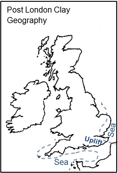
Figure 4 – Post London Clay Paleogeography The term London Basin is potentially confusing. Geologists tend to use the term ‘Basin’ to describe an actively subsiding marine area in which sediments are washed and deposited. Current mainstream geological thinking is that most of the folding that produced this ‘London Syncline’ and the Wealden anticline post-dates the deposition of the London Clay under London and Hampshire and as such didn’t create depositional London and Hampshire ‘basins’.
Faulting
Prior to the investigations for the Crossrail works it was commonly assumed by Geologists that geological faulting was relatively uncommon in London and was limited to a few well known large scale structures, like the Wimbledon, Streatham and Greenwich faults. This view arose from the depth of significant engineering works (i.e. they were mostly within the London Clay) and a lack of recognition of sub divisions in the London Clay, which can act as displacement markers. Greater understanding of the strata variations within the Lambeth Group and London Clay and deep infrastructure projects like Crossrail are showing that faulting within London is much more common and complex than previously assumed.
River Terrace Deposits
The River Terrace Deposits in London are a series of mostly sand and gravel terraces deposited by the Thames and associated with glaciation to the north of London. The base of the oldest and highest Terraces of the modern Thames in the London area are 90m above current sea level and the base of lowest / youngest are found well below the base of the Thames channel.
The earliest/highest terraces associated with the modern course of the Thames in London were formed after the course of the river was diverted by ice southwards from its former course through the St Albans area and out to sea in Essex to its current course through London. This diversion was caused by the southern extent of what Geologists call the ‘Anglian’ glaciation. This took place about 450,000 years ago and represents the farthest south the ice sheets came in the recent geological past. In the Anglian the ice sheets reached what is now the northern edge of London. This ice would have been many 100m’s thick in the Home Counties to the north of London.
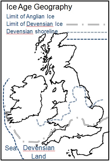
Figure 5 – Ice Age Paleogeography In all the several subsequent UK periods of glaciation the southern extent of the glaciation was farther to the north. The last significant glaciation in the UK (the ‘Devensian’) lasted about 100000 years, peaked about 22000 years ago and is considered to have ended about 10000 years ago. The Devensian ice extended as far south as a line between the Humber and Severn estuaries. The formation mechanism for the Terraces is complex, but it is recognised that all were formed in cold ‘glacial’ spells between the Anglian and Devensian glaciations.
From a deep engineering perspective the most important feature of the Terraces is the implied pulsed uplift required to lift older terraces to high above subsequent sea levels. Remember during glaciation sea levels were much lower and coastlines were far to the south and west of their current locations, see Figure 5.
These episodes of uplift also provided the impetus for the down cutting of new younger channels and the creation of new lower and younger floodplains with their own terraces.
Rebound of the land surface after glacial loading is a well known phenomenon and is the driver for this pulsed uplift. After any phase of unloading uplift is initially rapid and then continues at slower rates for many 1000s of years. The London area is still slowly recovering from the multiple phases of ice loading and unloading experienced over the last 1Ma and is now creeping at low but measurable rates of mm per year. Evidence is also emerging that South East England may still be being tectonically compressed from the south east.
These movements are demonstrated by analysis of radar data from satellites, something Crossrail is doing to track long term ground movements arising from their construction works. On a wider scale this data also shows that the uplift is not uniform and some areas settle rather than heave. Rates of uplift and settlement also vary from place to place.
The boundaries between areas of varying heave appear to be related to faulting, often picked out by the courses or former courses of Thames tributaries.
On a wide scale settlement is likely to be caused by either:
1) The widespread dewatering of the aquifers under London since the mid 19th Century, causing consolidation of the London Clay, or similar medium scale dewatering undertaken for projects like Crossrail. Central London is thought to have settled around 200mm since the mid-19th century because of this dewatering.
2) Or, in areas close to the lower Thames, by self-weight settlement of thick post glacial sequences of soft organic alluvial soils deposited in the estuary. These soils were deposited as sea level rose and flooded the lower parts of the Thames after the ice age ended.
Any interpretation of long term monitoring of the ground surface after Crossrail like works needs to take account of these different mechanisms, their varying rates, the directions in which they operate and the boundaries between different zones of movement.
Further Reading
The following contain more technical detail:
The Palaeogene/Neogene and Quaternary chapters in The Geology of England and Wales 2nd Edition published by the Geological Society
The British Geological Survey’s Special Memoir for London (covering the 1:50000 Geological Maps numbered E256-7, E270 and E271)
For less technical content try:
Southern England (Collins New Naturalist Library, Book 108): The Geology and Scenery of Lowland England by Peter Friend
References
King, C. (2006). Palaeogene and Neogene: uplift and a cooling climate. In: Brenchley, P.J. & Rawson, P.F. (eds.) The geology of England and Wales , 2nd edn, p. 395-428. The Geological Society, London.
Murray, J.W. (1992) Palaeogene and Neogene. In: The Atlas of Palaeogeography and Lithofacies, Geological Society, London, Memoirs, v13; p141-147
Graham, C.C. Straw, A. (1992) Quaternary. In: The Atlas of Palaeogeography and Lithofacies, Geological Society, London, Memoirs, v13; p149-153
Page, D. Skipper, J. (2000) Lithological Characteristics of The Lambeth Group. Ground Engineering February 2000.
Jolley, D.W. (1996) The earliest Eocene sediments of eastern England: an ultra-high resolution palynological correlation. In: Knox, R. W. O’B., Corfield, R. M. & Dunay, R. E. (eds), 1996, Correlation of the Early Paleogene in Northwest Europe, Geological Society Special Publication No. 101, pp. 219-254
Newell, J.N (2014) Palaeogene rivers of southern Britain: climatic extremes, marine influence and compressional tectonics on the southern margin of the North Sea Basin. Proceedings of the Geologists’ Association 125 (2014) 578–590
Aldiss, D. Burke, H. Chacksfield, B. Bingley, R. Teferle, N. Williams, S. Blackman, D. Burren, R. Press, N. (2014) Geological interpretation of current subsidence and uplift in the London area, UK, as shown by high precision satellite-based surveying. Proceedings of the Geologists’ Association 125 (2014) 1–13.
Royse, K.R. de Freitas, M. Burgess, W.G. Cosgrove, J. Ghail, R.C. Gibbard, P. King, C, Lawrence, U. Mortimore, R.N. Owen, H. Skipper, J. Geology of London, UK. Proceedings of the Geologists’ Association 123 (2012) 22–45
Jones, D.K.C. (1999) On the Uplift and Denudation of the Weald. In: Smith, B. J., Wuallzy, W. B. & Warke, P. A. (eds) 1999. Uplift, Erosion and Stability: Perspectives on Longterm
Landscape Development. Geological Society, London, Special Publications, 162, 25-43.
Bridgland, D. R. (2006) The Middle and Upper Pleistocene sequence in the Lower Thames: a record of Milankovitch climatic fluctuation and early human occupation of southern Britain, Henry Stopes Memorial Lecture 2004. Proceedings of the Geologists’ Association, 117, 281-305
-
Authors

John Davis EurGeol CGeol MSc DIC - Geotechnical Consulting Group
John was seconded to the Chief Engineers Group within Crossrail from Geotechnical Consulting Group LLP from 2009 until July 2016.
Within the Chief Engineers Group John was responsible for all Crossrail geotechnical matters east of Farringdon. Whilst at Crossrail John was also closely involved with the production of Geotechnical Baseline Reports for all the major Civils contracts. Prior to Crossrail John spent 20+ years as a geotechnical designer working on a diverse range of structures across the world, these included deep basements, embankments, tunnels, slopes and retaining walls. John was seconded to London Underground for a couple of years in the mid 90’s where he led a research programme on the impact of rising groundwater on the tube network.