Workflows for Managing Land and Property Information
Document
type: Micro-report
Author:
Milena Grujic BSc(Hons)
Publication
Date: 27/09/2016
-
Abstract
Crossrail needed to acquire and manage large areas of land during the Crossrail project, the purpose being to construct a new railway through Central London. This micro report outlines how the spatial element has been central to the management of this land from purchase and occupancy by a multitude of contractors, through to final handover to the appropriate owner. It demonstrates the importance of geospatial applications in both identifying land and understanding and minimising disruption at contract handover.
This paper is relevant to any project or people interested in efficiently managing Land and Property information.
-
Read the full document
Workflows for Managing Land and Property Information
Introduction and context
Crossrail is the largest project in London and the South East. The £14.8bn railway consists of 42km of new tunnels and 10 new stations, and has needed to acquire around 13,000 land and property interests over 4 years. One of critical phases in the Crossrail project was the property acquisition and planning phase, Crossrail construction could only begin once “Entry to land” had been facilitated following the serving of notices (entry was a minimum of 3 months after notice was served but in some cases longer).
The greatest challenge for the GIS (Geographic Information System) team was collating the vast quantities of data gathered from many different sources, supplied in different coordinate systems, huge volumes of Digital Terrain Models (DTM) throughout the Crossrail route and the integration of different systems. All this information needed to be seamlessly joined and integrated.
What did Crossrail Do?
The process commenced in April 2009 with the creation of the Final Land Acquisition Boundary (FLAB). The next step was producing depth (Z) values and finally the production of the General Vesting Declaration (GVD). This was a joint effort between the Delivery Management, CAD, GIS and Property Acquisition Teams.
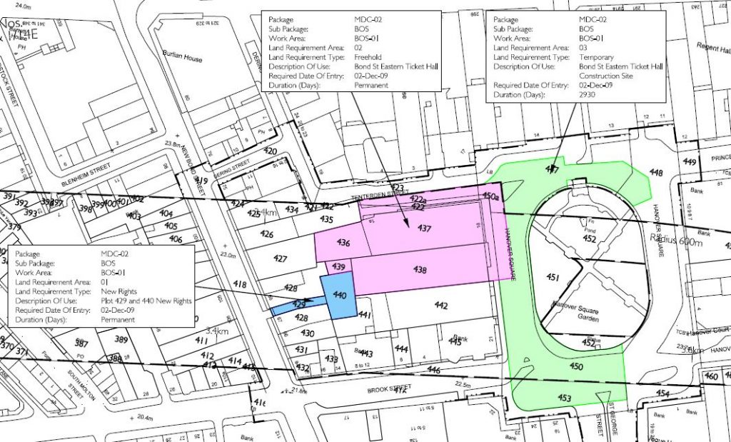
The Final Land Acquisition Boundary (Figure 1) represents the boundary of land that Crossrail required. Land Acquisition areas were divided into:
- Freehold
- Temporary Use – exclusive,
- Temporary Use – in common with others
- New Rights
These FLAB areas were derived using various sources such as the Parliamentary Plans and Schedules in the Act, and Engineering Drawings from the designers. The total Land Requirement could not exceed the Limits (Limit of Deviation (LoD) and Limit of Land to be Acquired or Used (LLAU)) defined in the Parliamentary Plans under the Crossrail Act and the similar Plans for the two Transport and Works Orders promoted for additional land at Plumstead and Kensal Green.
Figure 1 – Example of FLAB Drawing
At this time, the GIS team was working on utilising Oracle Spatial as a data repository with GIS workspace to create FLAB in Bentley Maps (Originally GeoGraphics). However due to time constraints and the job complexity it was decided to keep the attribute data inside an Access database file and geometry information within Bentley MicroStation format. Following this decision the spatial extension of FLAB areas were recorded digitally within the CAD system and then topologically cleaned; attributes captured onto the FLAB database were checked by the GIS Team. The final FLAB model (MicroStation (.dgn) and Microsoft Access Database (.mdb) files) was loaded into the Crossrail Property Register (CPR) web application. The CPR was hosted externally by Terraquest.
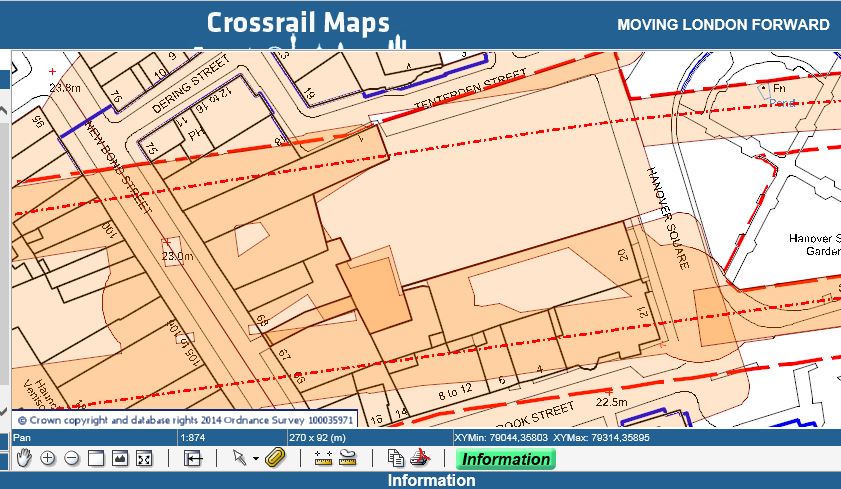
The approved FLAB Model was sent to the contractor to define the Land Acquisition Parcels (LAPs). This parcel information was used to obtain consent for acquisition. Once the FLAB was approved by the property team it was loaded into Crossrail Maps -a web based geographical system browser. Here the users could use different functionalities such as measurement tools, displaying multiple layers and various base maps; creating custom PDF printable purpose-specific maps used for checking gaps in the FLAB model and emailing changes for further editing (see Figure 2).
Figure 2 – Crossrail Maps
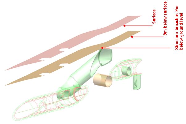
The property acquisition process was a very complex phase, working with huge amounts of data in both 2D and 3D plans. Land Acquired can be both Surface and Subsoil. Subsoil Rights were only sought where the upper level of strata required was more than 9m below ground level. If strata shallower than 9m were required acquisition of the whole (surface and subsoil) was required (see Figure 3). Generally all data outside stations was below 9m and could be acquired through General Vesting Declaration. Anything above 9m required the full compulsory purchase process.
Figure 3 – Subsoil FLAB identifies breach of 9m below surface (Isometric View)
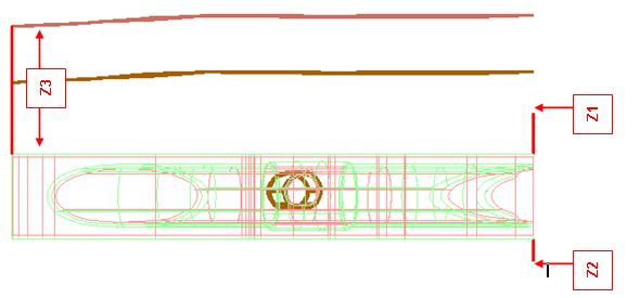
The acquisition of land involved the notification of owners and was based on the depth of the tunnel below the property – Z values (Figure 4).
Figure 4 – Subsoil showing Z Values (Front Elevation)
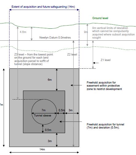
This process involved extracting the land parcel boundaries from the CPR into Crossrail GIS Environment (Oracle) together with the Digital Terrain Model (DTM) and the buffer around the tunnel alignment. The GIS Team was responsible for determining and updating the depth (Z) values in the CPR database. These values were defined as shown in Figure 5 below.
Figure 5 – Land Acquisition – Land Referencing Service Specification
The need for developing automated extraction of Z values and 3D PDFs was recognised at the start of the project, but was not achieved until 6 months later, due to the complexity of the data and resources available at the time. Once the process had been established the efficiency and the management of spatial data information improved dramatically.
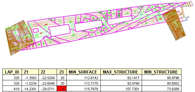
Figure 6 – Subsoil Land Parcels (Plan View) with Table of Z1, Z2 and Z3 Value
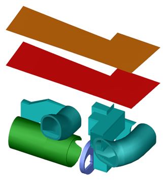
The parcel’s Z information (Figure 6) and 3D PDFs of Work Area (Figure 7) was then uploaded into the CPR application where this information was used to create GVD draft notices to be served for the acquisition of land.
Figure 7 – 3D PDF – Z values
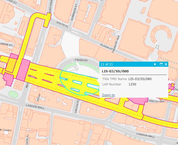
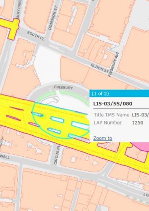
The Titles Management System (TMS) was used to import required data from the Crossrail Property Register (CPR). The spatial data relating to the property titles was passed to the Bentley Maps application. Title boundary was created by digitising the information within Bentley Maps, on completion it was inserted back into the Crossrail Oracle database. The TMS system managed the workflow for land registration and maintained links to the spatial data stored in the GIS application. This provided the ability for users to manage and query spatial data and associated land registry information via the Crossrail Maps interface (Figure 8).
Figure 8 – Displaying and Querying TMS Data using Crossrail Map
Lessons Learned and Recommendations for Future Projects
To ensure data integrity, Topology Cleanup utilities should be used to repair any errors prior to uploading geometry into a Property Register-style database.
Crossrail Maps played a key role in planning, identifying gaps in the final stage of property acquisition and consultation with 3rd parties. It produced awareness and effective management of spatial data; it was beneficial in identifying, understanding and minimising the disruption between contract handover. This was achieved by integrating Crossrail Maps with other project data and providing a seamless solution for use within the project.
-
Authors
Milena Grujic BSc(Hons) - Crossrail Ltd
Milena is Assistant GIS Data Manager. She is responsible for developing, maintaining, managing and making available geospatial project information required for Project progression. Milena has been with Crossrail for the last 7 years, prior to this she worked as a GIS consultant for Fugro (3 years) based in Aberdeen, and Agip working on the North Caspian Sea Project (3 years) based in London. She holds a BSc (Hons) degree in Topographic Science from the University of Glasgow.
